We’ve just revisited one of those places that makes you wonder what in the world you were thinking the last time you visited. Our only remembrance of the Metolius was when Sooney and I joined friends for a festive weekend many years ago, and we both have different recollections of that visit. The setting was a series of funky cabins encircling a larger dining room, and with Lake Creek meandering calmly in and around the buildings. I’ve learned that this creek is one of many that feeds into the Metolius a few hundred yards downstream. Everybody was sharing pot-luck and celebrating life in general. Aside from a bike ride to Camp Sherman, consisting of a general store and post office, the area is sparsely populated by resorts and private residences constructed in the 20’s and still retaining that era’s charm. This visit, however, has proven far more informative from a recreational perspective and we learned much about the area’s camping, fishing, and birding potential.
The Metolius River is a spring-fed river in central Oregon that flows eventually into the Deschutes River and that, in turn, flows in a northerly direction into the Columbia River and Pacific ocean. Today we walked along this beautiful trout stream to its headwaters, where water gently seeps out of a hillside about 12 miles from the touristy community of Sisters. A couple visitors recalled once seeing a steady flow from underground headwater heaven but that wasn’t the case today.
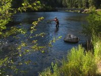
Yesterday, I hiked along a faster-flowing Metolius at another riverside campground (Canyon Creek), six miles downstream from Camp Sherman. By this time, additional water had joined the journey from smaller creeks. But the day’s highlight was discovering another underground water source a half-mile downstream that literally literally gushed water from six openings in a steep river bank. Interestingly, Sooney and her birding buddy, Susan, reached the same point an hour earlier from the other direction: the trail originates at the Wizard Falls Hatchery and, after crossing the river to its western bank, they walked upstream about 2.5 miles (south) to the Canyon Creek campground. Susan’s husband, John (my fishing partner) and I approached the same water from the north west, traveling remote forest roads in search of fishable water. The stretch of water at Canyon Creek is characterized by steep banks and deep, fast-flowing water, and the fish were hunkering safely down toward the bottom. (To be truthful, all fish are safe from me). Hence, Sooney and I enjoyed the same gorgeous experience at different times and from different directions. When we regrouped later that day, it was with wide eyes and we blurted almost simultaneously, “You’ll never guess what I saw today!”
We’re camping at the Lower Bridge Campground (Bridge 99) that pretty much concludes the easily-assessable sections of the Metolius. From here on, the river continues flowing northward and, with a few exceptions, is protected from vehicular traffic. Maps show fishing trails along both banks, and routes to the river from the Redmond side of the Cascade range. The campgrounds along the Metolius, and there are many, are mostly small (10-15 spaces) and most have water spigots but not much more. One place John and I fished is Allen Springs, and nearly every campsite is right on the water. That place merits another visit.
Something else we discussed is the option of renting one of the resort cabins near Camp Sherman that have decks right on the water. Visits in snowy January feature snow-shoe and cross-country skiing options up and down the river that would be fun.